

The Sky Was Clear. Then A Mountain Fell On Nepal.

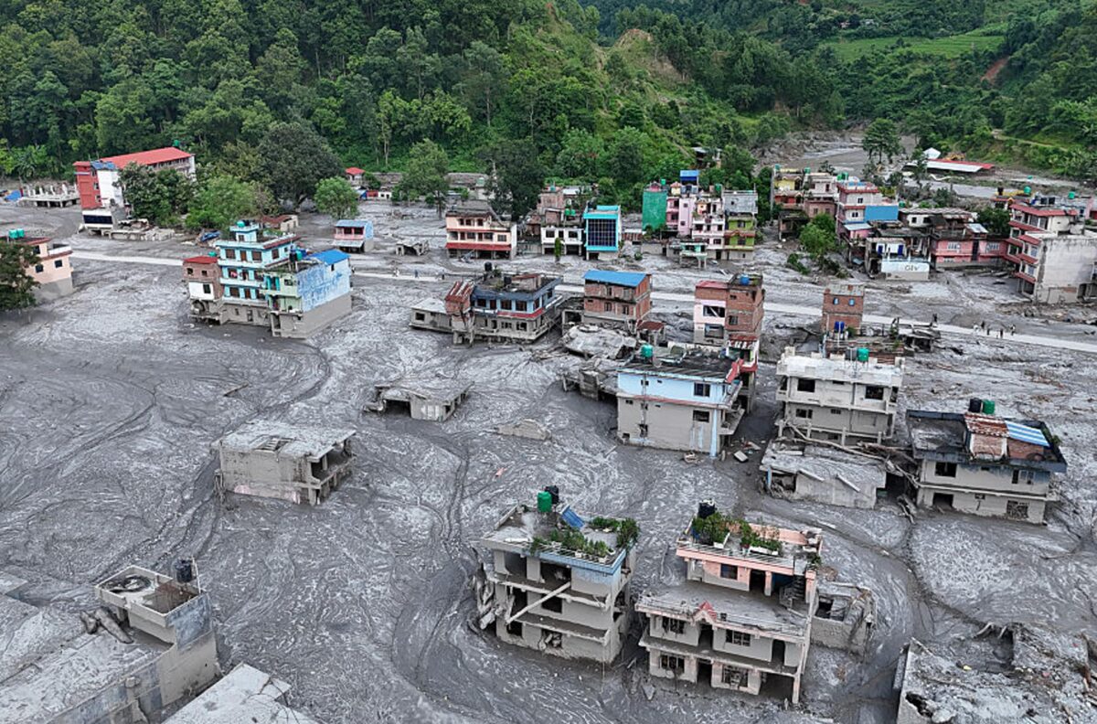
On a morning with no rain and no warning, a chunk of ice the size of dozens of football fields broke off a Himalayan peak and turned into one of Nepal’s deadliest disasters in decades. Here is what actually caused the flood, and what it has left behind.
The strange part of the Nepal floods is not just how deadly they became. It is that the sky was clear when it happened.
On the morning of August 26, 2026, a stretch of the Trishuli River system running through Nepal’s Rasuwa and Nuwakot districts, and across the border into Gyirong County in Tibet, was overwhelmed by a wall of water, mud, ice and rock that flattened a border crossing, buried villages, and swept away bridges, roads and hydropower stations across a 72 kilometre stretch. There was no storm to blame. Investigators would later trace the disaster back to something happening thousands of metres above the valley, out of sight of anyone below.
What Actually Caused The Flood
Scientists initially floated a few competing explanations, including an earthquake and a glacial lake bursting its banks. Analysis from the United States Geological Survey and Germany’s GFZ Helmholtz Centre for Geosciences eventually settled the question. A section of glacier on Langtang Lirung, roughly 0.2 square kilometres of ice and rock sitting at an altitude of around 5,200 metres, broke away and fell close to 1,200 metres down the mountainside. The impact itself generated a seismic signal strong enough to be picked up by monitoring stations around the world, which is why an earthquake was initially suspected. It wasn’t one. The tremor was the collapse, not the cause of it.
The falling ice and rock melted on impact from sheer velocity and friction, and that meltwater, mixed with rock and debris, surged into the valley below and displaced the river. Within seven minutes, the flood had reached and destroyed the Gyirong Port border crossing. Geologists estimate the debris moved at speeds close to 180 kilometres an hour and travelled roughly 100 kilometres downstream, leaving more than a metre and a half of silt across the disaster zone.
Scientists have connected the underlying instability to a warmer climate. Permafrost, which normally binds rock and ice together in high-altitude terrain, has been weakening under long-term warming trends, making this kind of sudden glacier collapse more likely even without any single dramatic weather event to trigger it.
Why The Warning System Missed It
Nepal and China have maintained a flash flood early warning system for years, and it has a track record of preventing casualties during the monsoon season. It was not built for this. The monitoring network was optimised to detect slower-building, rain-driven floods, not a glacier collapse that could send a wall of water down a valley within minutes. Upstream monitoring stations were themselves destroyed by the flood before any alert could be sent out, leaving downstream communities with almost no lead time. In at least one case, a headteacher evacuated 900 children from a school in Nuwakot just ten minutes before the flood arrived, relying on word of mouth warnings passed along by people further upstream rather than any official alert.
The Human And Economic Toll
The scale of the disaster has continued to grow in the days since. More than 950 people have died in Nepal, with over 4,700 still listed as missing, and 16 additional deaths confirmed on the Chinese side of the border. Bodies have been recovered as far as 240 kilometres downstream, some carried across the border into India.
The damage extends well beyond the death toll. Nepal’s government has estimated over 200 billion rupees, more than 1.3 billion US dollars, in initial damages, with the finance ministry warning full reconstruction could eventually cost around 5 billion dollars. At least 41 bridges and 42 kilometres of road were destroyed. Thirteen hydropower projects were damaged, knocking an estimated 431 megawatts of electricity off Nepal’s grid. Twenty schools across three districts were damaged, and roughly 1,200 people were displaced after entire village offices were washed away. The International Federation of Red Cross and Red Crescent Societies estimates that around 93,000 people have been affected in total.
A Global Response, And A Familiar Regional Tension
Nepal’s disaster drew aid pledges from more than a dozen countries, including the United States, United Kingdom, India, China, Australia, the UAE and South Korea, along with UN agencies, the Asian Development Bank and international humanitarian groups. India alone airlifted over 60 tonnes of relief supplies within days.
The flood has also reopened a familiar regional undercurrent. Some early social media speculation tried to link the disaster to Chinese infrastructure or dam activity upstream, reflecting years of tension between China and downstream countries like India over Himalayan water projects. Scientific analysis has since pointed clearly to the glacier collapse as the source, but authorities in both Nepal and China have had to actively push back against misinformation as the death toll climbed.
Frequently Asked Questions
What caused the Nepal floods in 2026?
A section of glacier on Langtang Lirung mountain collapsed and fell around 1,200 metres into the valley below. The impact melted the ice, and the resulting surge of water, rock and debris flooded the Trishuli River system, destroying the Gyirong Port border crossing within minutes.
Was the Nepal flood caused by an earthquake?
No. A seismic signal was detected at the time of the disaster, but scientists at the USGS confirmed the signal was generated by the glacier collapse itself, not by a tectonic earthquake.
How many people died in the Nepal floods?
As of early September 2026, more than 950 people had died in Nepal, with over 4,700 still missing. An additional 16 deaths were confirmed in Tibet, along with 546 people missing on the Chinese side of the border.
Why didn’t Nepal’s flood warning system detect the disaster in time?
The existing early warning system was designed to detect slower, monsoon-driven floods. It could not process a sudden glacier collapse, and upstream monitoring stations were destroyed by the flood before alerts could be sent.
How much damage did the Nepal floods cause?
Nepal’s government estimated more than 200 billion rupees, over 1.3 billion US dollars, in initial damages, with full reconstruction potentially costing around 5 billion dollars. Roads, bridges, schools and 13 hydropower projects were among the infrastructure destroyed.
Is climate change linked to the Nepal glacier collapse?
Scientists say rising temperatures have weakened the permafrost that normally holds high-altitude rock and ice together, making glacier collapses like this one more likely, even though this specific event was not directly triggered by a storm or rainfall.