Tropical Storm Erin emerges in Atlantic, could become first hurricane of 2025 season
Developing tropical storm near Cabo Verde could become Hurricane Erin this week.
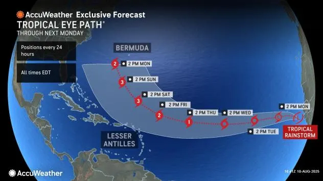
A new tropical system, now named Tropical Storm Erin, spun to life Monday morning over the eastern Atlantic and could intensify into the first hurricane of the 2025 Atlantic season within days.
By Monday afternoon, Erin was positioned just west of the Cabo Verde Islands off Africa’s coast. Packing sustained winds near 45 mph, the storm is moving steadily westward across a stretch of ocean meteorologists call the “main development region” — a prime breeding ground for powerful storms thanks to its warm waters. The National Hurricane Center (NHC) projects steady strengthening, with Erin potentially reaching hurricane status by Wednesday evening.
READ ALSO
Storm that could become Hurricane Erin: Here’s what US residents should know
Hurricane Erin likely? Tropical rainstorm in Atlantic expected to strengthen
While it’s far too early to know Erin’s eventual path or threat level to land, its journey toward the western Atlantic will unfold over the course of the week. Forecast models suggest the storm’s trajectory could be influenced by the Bermuda High, a sprawling high-pressure system that often acts like a steering current for tropical cyclones.
Conditions in Erin’s path appear primed for intensification. Sea surface temperatures are significantly warmer than average, although slightly below the record heat of 2023 and 2024. If the storm taps into this energy-rich environment, it could make a rapid leap to major hurricane strength — Category 3 or higher — possibly by Saturday.
August marks the historical peak of Atlantic hurricane season, with activity typically surging from mid-August to mid-October. So far in 2025, the season has produced four named storms — Andrea, Barry, Chantal, and Dexter — but no hurricanes. That’s in line with historical trends, as the first hurricane usually develops around August 11.
The NHC is also monitoring two additional systems over the central and eastern Atlantic. Both have low odds of development in the next few days but signal that the tropical basin is shifting into high gear.
How the Bermuda High Shapes Hurricane Paths
The Bermuda High is a large area of high pressure that often sits over the Atlantic during summer. Think of it as a massive atmospheric “traffic director” for tropical storms:
-
Strong & well-positioned east → pushes storms westward toward the Caribbean or U.S. East Coast.
-
Weaker or shifted north → allows storms to curve into the open Atlantic and away from land.
Erin’s eventual path could depend heavily on where the Bermuda High settles later this week.