

Indonesia earthquake: Magnitude 7.7 quake kills 47 as landslides trap survivors

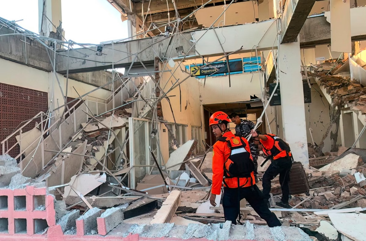
Rescuers working amid the rubble of a damaged building after an earthquake in Maumere, East Nusa Tenggara. Handout / INDONESIA’S NATIONAL SEARCH AND RESCUE AGENCY (BASARNAS) / AFP via Getty Images
A powerful magnitude 7.7 earthquake struck off Indonesia eastern Flores region, killing at least 47 people and damaging homes, schools, health facilities and other buildings, according to authorities cited by NBC News.
The earthquake struck off the coast of East Nusa Tenggara province, with the epicentre reported about 42 miles north-northwest of Ende. The strong undersea earthquake prompted Indonesian authorities to issue a tsunami warning and urge people in vulnerable coastal areas to move away from beaches and riverbanks.
Rescue operations have been complicated by landslides, blocked roads and disrupted communications, leaving some communities difficult to reach.
Where Did the Indonesia Earthquake Strike?
The earthquake occurred in the eastern Flores region, an area that includes communities on and around Flores Island. The United States Geological Survey reported the magnitude-7.7 earthquake, while Indonesian authorities warned residents in several provinces following the tremor.
The epicentre was located offshore near Flores Island, approximately 42 miles north-northwest of Ende in East Nusa Tenggara.
The earthquake was felt across large parts of Flores, where residents reported severe shaking and structural damage. In some communities, people rushed out of buildings in fear of collapse.
Indonesia Earthquake Death Toll Rises to 47
Indonesia’s National Disaster Management Agency reported that at least 47 people had died following the earthquake.
Rescuers in the port town of Maumere reported finding 20 bodies, while six people were injured and two others were trapped under rubble, according to the report.
Officials warned that the death toll could change as rescue teams reach areas that remained difficult to access.
Nagekeo, the region closest to the earthquake’s epicentre, was among the areas where rescue operations faced major obstacles. Landslides reportedly blocked roads and communications were disrupted.
Landslides Complicate Rescue Operations
The earthquake caused significant damage to infrastructure across affected areas. Preliminary figures cited in the report indicated that 157 homes were heavily damaged, while 41 suffered moderate damage and another 148 sustained light damage.
Damage was also reported at 87 schools, 18 health facilities, five places of worship and six office buildings.
The scale of the destruction has made access a major challenge for emergency responders. With roads blocked by landslides, rescuers have had difficulty reaching some communities and determining the full extent of the damage.
Residents described scenes of panic as people fled damaged buildings and moved toward safer areas.
READ ALSO
Tsunami Warning Issued After Undersea Earthquake
Indonesian authorities initially issued a tsunami warning for parts of East Nusa Tenggara, West Nusa Tenggara, South Sulawesi and Southeast Sulawesi.
Residents were urged to stay away from beaches and riverbanks, while people living along the coastline were told to move to higher ground.
The earthquake was described as a shallow undersea quake near Flores Island. The initial earthquake was followed by two aftershocks, adding to concerns among residents already dealing with damaged buildings and disrupted infrastructure.
Australia’s tsunami warning centre separately said the earthquake posed no tsunami threat to mainland Australia, its islands or territories, according to the report.
Buildings Collapse as Residents Flee
The force of the earthquake caused buildings to collapse in some affected communities.
At St. Peter Major Seminary in Sikka, students attending morning Mass reportedly fled after the roof of an assembly hall collapsed. The rector, Rev. Guidelbertus Tanga, said students and nuns ran from the building as the quake struck.
At least one priest reportedly suffered a broken leg after jumping from the second floor.
In Maumere, residents also reported damage to buildings, including the collapse of a waiting area at a port terminal.
The reports highlight the widespread impact of the earthquake across Flores and surrounding areas.
Why Is Indonesia Prone to Earthquakes?
Indonesia experiences frequent earthquakes and volcanic activity because it sits along the Pacific Ring of Fire, an area associated with numerous fault lines and volcanoes.
The country’s location means major earthquakes can occur both on land and beneath surrounding seas. Undersea earthquakes can also create tsunami risks, making early warnings and rapid evacuation particularly important for coastal communities.
Flores has experienced devastating earthquakes and tsunamis in the past. In December 1992, a magnitude-7 earthquake triggered a tsunami that killed about 2,500 people on Flores, according to the report.
Rescue Efforts Continue Across Affected Areas
Emergency teams are continuing to search damaged buildings and assess the destruction caused by the latest earthquake.
The biggest challenges include reaching isolated communities, clearing roads blocked by landslides and restoring communications. Officials are also assessing damage to homes and essential public infrastructure.
As rescue teams reach more affected locations, authorities are expected to provide updated casualty figures and further information about the scale of the destruction.
For now, residents in affected areas remain on alert as emergency agencies respond to one of the strongest earthquakes to strike the region in recent years.
Indonesia Earthquake FAQ
What happened in Indonesia?
A magnitude 7.7 earthquake struck off the coast of Flores Island in eastern Indonesia on August 15, 2026, causing widespread damage, landslides and casualties. The epicentre was about 68 kilometres (42 miles) north-northwest of Ende in East Nusa Tenggara.
How many people died in the Indonesia earthquake?
At least 47 people were reported dead following the earthquake. The casualty figure could change as search-and-rescue teams reach areas that remain difficult to access.
Where did the Indonesia earthquake happen?
The earthquake struck off Flores Island, in Indonesia’s East Nusa Tenggara province. Areas including Nagekeo, Sikka and Maumere were among those reporting significant impacts.
How strong was the Indonesia earthquake?
The earthquake had a magnitude of 7.7, making it a powerful earthquake capable of causing severe damage, particularly near the epicentre. The quake was relatively shallow, with the USGS reporting a depth of about 10 kilometres.
Was there a tsunami after the Indonesia earthquake?
Yes. Indonesian authorities initially issued a tsunami warning after the undersea earthquake. The warning was later lifted after monitoring indicated that there was no continuing major tsunami threat. Small tsunami waves were recorded in some coastal areas, with reports of a wave reaching about 1.61 metres in Riung.
Is there still a tsunami warning in Indonesia?
The initial tsunami warning was lifted. However, residents in affected areas were dealing with aftershocks and damage, so authorities continued emergency assessments and advised people to remain cautious.
How many people were injured in the earthquake?
Dozens of people were injured, with reports varying as authorities continued gathering information. Rescue teams were also searching damaged buildings for people who could still be trapped.
What areas were worst affected by the Flores earthquake?
Nagekeo and parts of Sikka and Manggarai were among the badly affected areas. Maumere also reported deaths, collapsed structures and significant damage. Landslides made access to some communities particularly difficult.
How much damage did the Indonesia earthquake cause?
Early assessments indicated that hundreds of homes were damaged or destroyed, along with schools, health facilities, government buildings and other infrastructure. About 2,000 residents in Nagekeo were reported to have evacuated to temporary shelters.
Why are rescue efforts difficult in Flores?
Landslides, blocked roads, power outages and communication disruptions have slowed emergency operations. Some roads, including sections of the Trans-Flores highway, were blocked, making it difficult for rescue teams to reach remote communities.
Were there aftershocks following the earthquake?
Yes. More than 200 aftershocks were reported following the main earthquake, including at least one tremor above magnitude 6. Aftershocks can pose additional risks to people near damaged or weakened buildings.
Why does Indonesia experience so many earthquakes?
Indonesia is located along the Pacific Ring of Fire, a highly active zone where tectonic plates interact. This geological setting makes the country particularly vulnerable to earthquakes, volcanic eruptions and, in some cases, tsunamis.
Has Flores experienced a major earthquake before?
Yes. Flores has a history of destructive earthquakes and tsunamis. A magnitude 7.7 earthquake in 1992 generated a devastating tsunami that killed more than 2,000 people on Flores.
What should people in an earthquake-affected area do now?
People should follow instructions from Indonesian disaster authorities, remain alert for aftershocks, avoid damaged buildings and stay away from unstable slopes and coastal areas when authorities issue warnings. People should also avoid returning to damaged structures until they have been assessed as safe.
Is the Indonesia earthquake situation still developing?
Yes. Search-and-rescue operations and damage assessments are continuing, particularly in communities affected by landslides and poor communications. The reported death toll and damage figures may change as emergency workers gain access to more affected areas.