UK weather alert: Torrential rain and widespread flood warnings as storm systems hit England and Wales
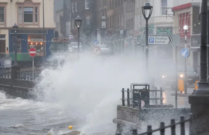
Storm Floris is expected to bring strong winds and heavy rain to the UK on Monday, with a yellow weather warning already issued for the northern half of the country. Photo credit: Reuters
The UK is gearing up for a turbulent stretch of weather as a series of powerful rain systems sweep across the country, prompting widespread warnings of flooding, travel disruption and dangerous conditions. Meteorologists predict that some regions could see an entire month’s worth of rain fall within just 24 hours, placing communities on high alert as emergency agencies activate flood response plans.
Heavy rainfall, strong winds and saturated ground conditions form the perfect storm expected to impact millions beginning late Sunday into early next week.
Amber ‘Danger to Life’ Warning for South Wales
Forecasters have issued an amber rain warning for parts of South Wales, signalling a high risk of flooding and potential danger to life. Up to 100–200mm of rainfall is expected in some areas — a severe blow following what has already been one of the wettest months of the year.
Meteorologists warn that swollen rivers combined with continuous downpours could lead to rapid flooding of homes, businesses and major routes.
The Met Office raised its impact level due to the likelihood of travel chaos, power interruptions and rising river levels across valleys and low-lying communities.
Yellow Alerts Sweep Across England and Scotland
Beyond South Wales, a wide stretch of the UK is under yellow rain warnings, including:
-
London and South East England
-
South West England
-
West Midlands
-
East Midlands
-
North West England
-
Yorkshire and Humber
-
South West Scotland
From midnight Monday to early Tuesday, these regions could see 20–40mm of rain generally and up to 120mm over higher terrain such as the Cumbrian fells. Strong southwesterly winds are also expected, particularly along exposed coastlines and upland areas.
Overnight ice warnings for northern England also raise concerns about slippery roads, dangerous footpaths, and travel delays.
Emergency Agencies Urge Immediate Vigilance
Natural Resources Wales and the Environment Agency in England have issued dozens of flood alerts, warning residents to prepare for possible evacuations or property damage.
With rivers already full and the soil heavily saturated, even moderate rainfall could trigger surface flooding. Richard Preece, duty tactical manager for NRW, urged the public to act now:
-
Check local flood risk zones
-
Sign up for emergency alerts
-
Avoid driving through floodwater
-
Prepare sandbags and protect valuables
Weekend and Early Week Forecast at a Glance
Today:
Most areas enjoy a brief window of calm with sunny intervals, though coastal counties in the north and northwest experience scattered showers, turning wintry over high ground. Conditions deteriorate later as rain moves in from the west.
Tonight:
A cold, clear evening in eastern regions with pockets of frost. Heavy rain and brisk winds spread from the west overnight, with snow expected across the Scottish mountains.
Monday:
Persistent downpours across southwest England and South Wales bring a high risk of flooding. Windy conditions push gales along western coasts. Northern areas see some improvement and brighter spells.
Tuesday to Thursday:
Showers dominate through midweek, especially in southern and western regions. Temperatures stay near average for early December, with occasional dry breaks.
Scotland Battles Power Outages After Severe Winds
The chaotic weather has already left its mark in Scotland. Strong gales reaching 83mph on the Western Isles and 75mph on the Isle of Mull knocked out power for around 1,000 homes before restoration efforts began. Though Friday’s wind warnings have expired, unsettled conditions remain likely.
FAQs
1. Why is the UK experiencing so much rain?
A series of Atlantic weather systems are driving continuous bands of heavy rain across the country, intensified by saturated ground and seasonal temperature shifts.
2. What does an amber warning mean?
It signals a high likelihood of dangerous conditions, including flooding, travel disruption and potential risk to life.
3. Which areas will see the heaviest rainfall?
South Wales is expected to receive up to 200mm of rain, with higher regions like Cumbrian fells seeing up to 120mm.
4. Are strong winds also expected?
Yes. Coastal and upland areas could experience gales, particularly in the west.
5. How long will this unsettled weather last?
The UK is expected to see changeable conditions through the coming week, with showers and intermittent dry spells.