What do hurricane categories 1 to 5 really mean — and where does Erin fit in?
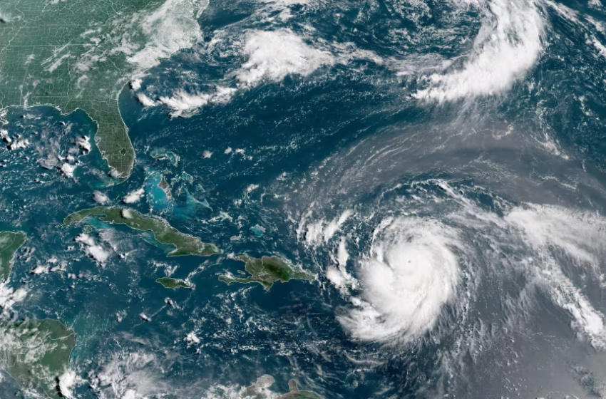
Hurricane Erin, which is the first hurricane of the 2025 Atlantic season and has developed into a dangerous Category 4 hurricane, moves westward near Puerto Rico in a composite satellite image on Saturday. Cira/NOAA/Reuters
When tracking storms like Hurricane Erin, U.S. residents often hear terms like “Category 3 hurricane” or “Category 5 monster storm.” These labels come from the Saffir–Simpson Hurricane Wind Scale (SSHWS), a system that ranks hurricanes by their sustained wind speeds and potential for destruction. Understanding each category is critical because the difference between them can mean the difference between minor inconvenience and catastrophic loss. Erin’s evolution through different levels of intensity provides a clear, real-time example of how this scale works and why it matters.
Category 1: The Starting Point (74–95 mph winds)
Category 1 storms bring what experts call “very dangerous winds.” At this stage, damage may not look catastrophic, but it is still disruptive. Roof shingles can be blown away, gutters may detach, and large tree branches often break. Power outages are common, especially in neighborhoods with overhead power lines. A U.S. example is Hurricane Irene in 2011, which came ashore in North Carolina as a Category 1 storm but went on to cause widespread flooding and billions of dollars in damage as it moved north. Hurricane Erin, like most storms, passed through this stage early on, proving that even the “weakest” hurricanes can be both costly and life-threatening.
Category 2: Stronger Winds, Greater Risk (96–110 mph winds)
At Category 2, winds are described as “extremely dangerous,” and the risks escalate quickly. Entire sections of roofing can be torn away, shallow-rooted trees often topple, and power outages may last for days or even weeks. Coastal areas face higher risks of storm surge flooding as well. A clear example for U.S. residents is Hurricane Frances in 2004, which hit Florida as a Category 2 hurricane and left millions without power while inflicting major structural damage. As Erin intensified, it crossed this threshold, signaling to Puerto Rico and the Virgin Islands that long-term utility disruptions and infrastructure damage were a serious possibility.
Category 3: The Major Hurricane Threshold (111–129 mph winds)
Category 3 storms mark the transition into “major hurricane” territory. Winds at this level can cause devastating damage, ripping away large sections of roofs, knocking down trees across homes and roads, and making some communities uninhabitable for weeks or longer. Storm surges also become far more dangerous and life-threatening. One of the most infamous examples is Hurricane Katrina in 2005, which was a Category 3 storm when it made landfall in Louisiana. Although the catastrophic flooding was largely due to levee failures, the wind and surge impacts were in line with the destructive force of a major hurricane. Erin currently sits at this level, with maximum sustained winds of 125 mph, making it a dangerous and destructive storm even if it avoids a direct hit on the U.S. mainland.
READ ALSO
Hurricane Erin weakens to category 3 but expected to regain strength… what this means
Category 4: Catastrophic Impact Zone (130–156 mph winds)
At Category 4, the damage potential becomes catastrophic. Homes can lose most of their roofs or suffer structural failure, entire power grids are often destroyed, and storm surges can devastate coastal regions. Communities may become uninhabitable for weeks or months. An example is Hurricane Laura in 2020, which made landfall in Louisiana as a Category 4 hurricane with winds of 150 mph, leaving behind destruction so severe that some neighborhoods were reduced to rubble. Forecast models suggest Erin could intensify back into Category 4 strength after completing its eyewall replacement cycle, a reminder that its current weakening should not be seen as an all-clear signal.
Category 5: The Worst of the Worst (157+ mph winds)
Category 5 hurricanes are rare but unforgettable. With sustained winds of 157 mph or greater, these storms flatten neighborhoods, destroy critical infrastructure, and produce storm surges capable of wiping out entire coastal towns. Recovery can take months or even years. Two stark examples are Hurricane Andrew in 1992, which devastated South Florida with winds of 165 mph, and Hurricane Michael in 2018, which slammed into the Florida Panhandle as a Category 5, leveling Mexico Beach and leaving long-lasting scars. Just two days ago, Erin briefly peaked at Category 5 strength north of the Caribbean, a chilling reminder of how quickly today’s hurricanes can intensify and why preparedness is so critical.
Why This Matters for U.S. Residents
For residents along the U.S. mainland, Erin’s evolution across these categories underscores a vital lesson: no hurricane category is “safe.” Even Category 1 storms can knock out power for days and cause significant flooding, while Category 5 storms can erase entire communities from the map. For now, forecast models suggest Erin will steer between Bermuda and the U.S. East Coast, sparing the mainland from a direct hit. But indirect impacts are still expected, including dangerous surf and rip currents from Florida through New England, beach erosion along the Carolinas, and hazardous marine conditions.
The key takeaway for Americans is simple: whether a hurricane is labeled a Category 1 or Category 5, preparation is essential. Erin’s rapid rise to Category 5, its current status as a Category 3, and its potential to strengthen again show how quickly conditions can change. The Saffir–Simpson scale provides a useful guide, but the real message is that all hurricanes demand respect, vigilance, and readiness.