Will Tropical Storm Humberto hit the US East Coast? What is the Fujiwhara effect?
Hurricane Erin, which is the first hurricane of the 2025 Atlantic season and has developed into a dangerous Category 4 hurricane, moves westward near Puerto Rico in a composite satellite image on Saturday. Cira/NOAA/Reuters
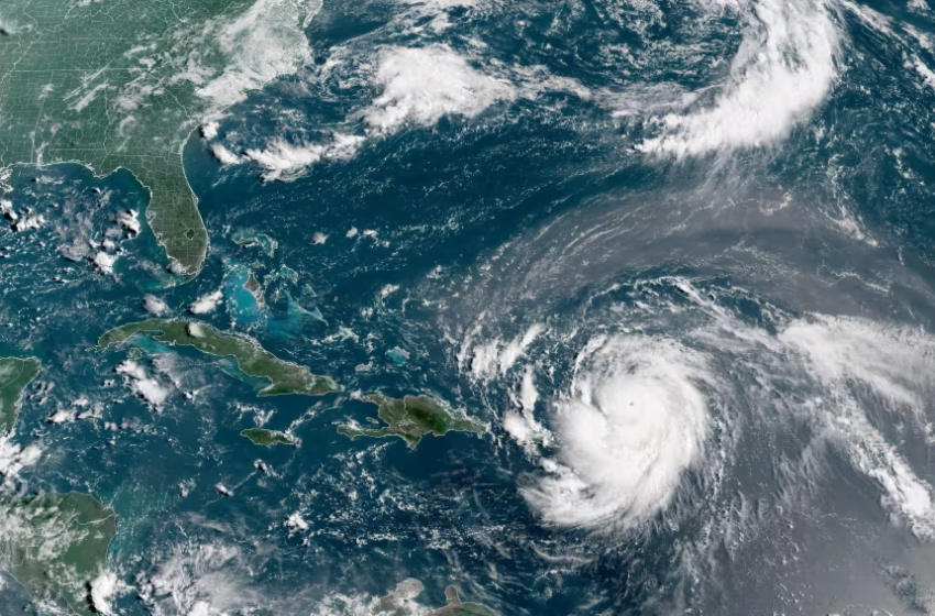
Tropical Storm Humberto is rapidly intensifying in the central Atlantic and is forecast to become a major hurricane by the weekend. While Humberto itself is unlikely to threaten the U.S. directly, forecasters are closely tracking another system that could have more serious implications. A tropical wave, designated Invest 94L, is moving across Hispaniola and has already unleashed heavy rainfall and flooding in Puerto Rico, the Dominican Republic and Haiti. As it moves toward the Bahamas, it is expected to strengthen into Tropical Storm Imelda, potentially becoming a significant threat to parts of the Southeast U.S.
Humberto, currently located several hundred miles east-northeast of the Leeward Islands, is gaining strength and is likely to become the season’s third hurricane. Bermuda could feel its effects early next week, but the storm is not projected to make a direct U.S. landfall. The more pressing concern lies with Invest 94L. After drenching parts of the Caribbean, the system is expected to organize near the Bahamas over the weekend, at which point it could develop into Tropical Storm Imelda. Forecast models suggest two main scenarios. One possibility is that Imelda moves northward and makes landfall in Georgia or the Carolinas early next week, arriving as either a tropical storm or hurricane. Another outcome is that it stalls offshore for a time before being pulled away into the Atlantic or absorbed by Humberto.
Even if Imelda never reaches land, both systems together could stir up hazardous conditions along the U.S. East Coast. Days of onshore winds are likely to create dangerous surf, rip currents and some coastal flooding from Florida to New England. Strong wind gusts are possible in parts of the Southeast, while heavy rain could exacerbate flash flooding risks in already saturated areas of the Carolinas and Virginia.
Adding to the uncertainty is the possibility of the Fujiwhara effect, a rare phenomenon in which two tropical systems get close enough to interact. In some cases, storms of similar strength orbit around a shared point before moving off in new directions. If one storm is stronger, it may absorb the weaker one, while in rare instances two storms can merge into a single larger system. How Humberto and a potential Imelda might influence each other remains unclear, but the outcome could significantly reshape their tracks and intensities.
With so many variables at play, forecasters caution that the coming days will be critical. For now, residents in the Bahamas, Bermuda and along the U.S. East Coast — particularly from Florida through the Carolinas — are urged to stay alert and monitor updates as the situation develops.
FAQ
Q: Will Tropical Storm Humberto hit the U.S.?
A: No, Humberto is expected to strengthen into a hurricane but poses little direct threat to the U.S. mainland. Bermuda could experience impacts early next week.
Q: What is Tropical Storm Imelda and why is it a concern?
A: Imelda, currently forming from a tropical wave near the Bahamas, could strengthen into a tropical storm or hurricane and potentially impact the U.S. Southeast coast next week.
Q: What is the Fujiwhara effect?
A: The Fujiwhara effect occurs when two storms get close enough to interact, potentially orbiting each other, merging, or one storm absorbing the other.
Q: Which areas should monitor these storms closely?
A: Residents in the Bahamas, Bermuda, and the U.S. East Coast, especially from Florida through the Carolinas, should keep a close watch for updates.
Q: What impacts could occur even if Imelda doesn’t make landfall?
A: Dangerous surf, rip currents, coastal flooding, heavy rainfall, and gusty winds are still likely along the Eastern Seaboard due to both Humberto and Imelda stirring the Atlantic.
Explainer: What to Know About Tropical Storm Humberto
Tropical Storm Humberto is one of the latest systems to develop during the busy Atlantic hurricane season. The storm formed a few hundred miles east-northeast of the Leeward Islands and is moving northwest across open waters. While it poses no threat to the Caribbean, forecasters warn it is gaining strength and is expected to become the season’s third hurricane.
Meteorologists are closely monitoring Humberto’s path, with projections showing it could near Bermuda early next week. Although it is unlikely to directly strike the U.S. mainland, Humberto could still contribute to dangerous surf, rip currents, and coastal flooding along the Eastern Seaboard.
The storm is intensifying because of deep, warm ocean waters — prime fuel for tropical systems this time of year. Forecasters caution that even if Humberto doesn’t make landfall, its presence in the Atlantic will combine with other systems, like the developing Tropical Storm Imelda, to create a volatile weather pattern.
What makes Humberto especially interesting is its potential to interact with Imelda through a rare meteorological phenomenon known as the Fujiwhara effect. In this scenario, two storms move close enough to influence each other’s tracks — sometimes spinning around a shared center or even merging. While not yet certain, this possibility adds another layer of complexity to Humberto’s forecast.
For now, the National Hurricane Center urges residents of Bermuda, the Bahamas, and the U.S. East Coast to remain vigilant. Even without a direct hit, Humberto’s swirling winds and waves can ripple far beyond its forecast path, proving that in hurricane season, distance doesn’t always mean safety.