Storm that could become Hurricane Erin: Here’s what US residents should know
Developing tropical storm near Cabo Verde could become Hurricane Erin this week.
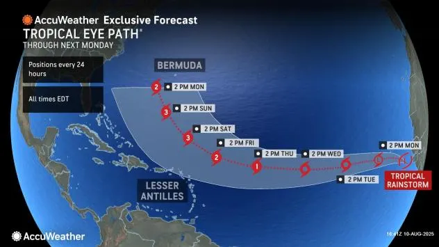
Meteorologists are closely tracking a tropical rainstorm in the eastern Atlantic, near the Cabo Verde Islands, which could strengthen into Hurricane Erin later this week — potentially becoming the first hurricane of the 2025 Atlantic season.
The system, which formed from a cluster of showers and thunderstorms that moved off the African coast, is expected to move westward over warm Atlantic waters through midweek before likely turning north by the weekend. This shift, guided by upper-air patterns, could spare the U.S. East Coast from a direct hit. However, forecasters warn that it may still generate rough surf and dangerous rip currents along beaches from the Carolinas to New England.
READ ALSO
Hurricane Erin likely? Tropical rainstorm in Atlantic expected to strengthen
In the short term, the Cabo Verde Islands may experience locally heavy rain and gusty winds through early this week. By late week, the storm’s projected northward turn could place it east of the Caribbean, though the exact track remains uncertain. Should the system strengthen as expected, it will be named Erin, and residents in the northern Caribbean, Bermuda, and parts of the U.S. East Coast will need to monitor updates for potential impacts.
Meanwhile, two other areas of interest are being watched in the Atlantic — one over the central basin with a low chance of development, and another cluster of storms set to move off Africa later this week that could threaten the Caribbean in the longer term.
The meteorological backdrop — why forecasters are watching
-
Favorable environment: Warm Atlantic sea surface temperatures, low wind shear in the system’s immediate vicinity, and limited Saharan dust are all factors conducive to intensification. These same ingredients explain why the disturbance could strengthen into a named storm — and potentially into the season’s first hurricane.
-
Steering currents matter: The ultimate path depends less on how strong it becomes and more on the mid- to upper-level atmospheric flow (the Bermuda High, troughs digging off the East Coast, and the subtropical jet). A stronger system can also alter its own environment and the steering flow locally.
-
Timing of the northward turn: Forecast guidance suggests (but does not guarantee) a northward turn by late week into the weekend. If that turn occurs well east of the U.S., the greatest impacts will be offshore. If the turn is delayed or weaker, the system could track farther west and bring greater threats to the Caribbean or U.S. East Coast.
Plausible track scenarios and U.S. implications
-
Most likely (based on current pattern): Turns north, stays well offshore
-
Impacts to U.S.: Elevated surf and dangerous rip currents from the Southeast up through the Mid-Atlantic and New England beaches; possible long-period swell, beach erosion, and localized coastal flooding on high tides; little or no direct wind or rain onshore.
-
Timing: Rip current and surf impacts would most likely begin late in the weekend into early next week as the storm moves north and its swell propagates toward the U.S. coast.
-
-
Lower-probability (storm curves north but closer to the coast)
-
Impacts to U.S.: Stronger surf, more widespread coastal flooding at high tide, and gusty onshore winds in coastal communities; possible tropical-storm-force gusts on exposed headlands and barrier islands if the storm stays nearer to the east coast.
-
Timing: Late week into next week; watches/warnings may be required if guidance converges on a closer approach.
-
-
Least likely (storm tracks farther west before recurving)
-
Impacts to U.S.: Potential direct impacts to the Southeast or the mid-Atlantic (wind, rain, storm surge) — this is a scenario to monitor but is not the current consensus.
-
Timing: Would depend on how long the westward component persists; impacts would arrive later than the other scenarios.
-
Region-by-region outlook for US
-
Florida (Atlantic coast): Main risk is increased surf and rip currents. Beachgoers should exercise caution beginning late weekend; a closer approach could bring higher beaches and localized coastal flooding.
-
Southeast coast (Georgia, South Carolina, North Carolina): Expect surf and rip currents; southern Outer Banks could see higher waves and beach erosion. If the system tracks closer, coastal flooding and gusty winds are possible.
-
Mid-Atlantic (Virginia to New Jersey): Rip current threat and elevated surf likely if the system turns north as expected; monitor high tide cycles for minor flooding in vulnerable inlets and low-lying areas.
-
New England: Longer-period swell may build; dangerous rip currents and increased surf can affect beaches, especially on exposed southern-facing shores.
-
Bermuda & the northern Caribbean: If the storm takes a more westward track before recurving, these areas should be on alert. Current indications place the most risk east of the Caribbean, but the situation is fluid.
Timing — what to expect and when
-
Next 48–72 hours: Further organization and possible tropical-storm classification; local impacts to Cabo Verde (rain, gusts).
-
Late week into weekend: Forecast models suggest a northward turn; U.S. coastal surf and rip currents may increase during this window.
-
Early next week: Depending on evolution, surf and coastal flooding impacts along the East Coast could peak.
Practical advice for US residents
-
Beachgoers and coastal residents: Heed lifeguard warnings and avoid entering the water if rip currents are reported; move valuables off low-lying areas if forecasts suggest increased coastal flooding on high tide.
-
Boaters and mariners: Monitor marine forecasts and consider avoiding exposed waters during swell events; expect higher seas and challenging conditions.
-
Emergency planners and local officials: Keep forecasts under review; prepare to issue targeted advisories (rip current, high surf, coastal flood) rather than broad evacuations at this stage.
-
Everyone: Follow official sources (National Hurricane Center, local NWS offices, and trusted meteorological outlets) for the latest watches, warnings, and forecast adjustments.
Uncertainty and how to follow updates
Forecast confidence improves as the system evolves and model solutions converge. Right now, the most probable outcome for the U.S. is indirect impacts (surf, rip currents, beach erosion) rather than landfall. That can change if steering patterns shift. Check updates from the National Hurricane Center (NHC), your local National Weather Service office, and trusted forecast outlets twice daily — or enable official alerts.
At present, the storm near Cabo Verde has the potential to become Hurricane Erin, but the dominant U.S. risk for most scenarios is dangerous surf and rip currents rather than a direct hit. Coastal communities from Florida to New England should watch the system closely over the next few days and prepare for offshore impacts even if the storm ultimately stays well to sea.