Storm Floris: What UK residents need to know about incoming wind and rain warning
Storm Floris: What UK Residents Need to Know About the Incoming Wind and Rain Warning
As the UK prepares for the arrival of Storm Floris, residents across the northern and coastal regions are being urged to brace for severe weather conditions early next week. With gusts potentially reaching up to 85mph and heavy rainfall forecast, the Met Office has issued a yellow warning covering large parts of the country. While summer storms are not entirely rare, Floris stands out due to its timing, intensity, and the widespread disruption it could cause to travel, infrastructure, and outdoor activities. This guide breaks down everything you need to know—how the storm formed, where it will hit hardest, and what steps you should take to stay safe.
What is Storm Floris?
Storm Floris is the sixth officially named storm of the UK’s storm season and the first to be declared since January. Named by the UK Met Office, this storm is expected to hit on Monday, bringing with it strong winds, heavy rainfall, and the potential for widespread disruption. Named storms are designated when forecasters believe a weather system could cause significant damage or interruption to everyday life. Floris fits this criteria due to its projected wind speeds and heavy rainfall, particularly across northern and coastal regions.
READ ALSO
Storm Floris set to batter UK with fierce winds and heavy rain
How Storm Floris Formed
The origins of Storm Floris can be traced back to a weather disturbance over the Great Lakes region in North America. Initially a band of heavy showers, the system began moving eastward across the Atlantic Ocean. Once it encountered a powerful jet stream—a fast-moving air current in the upper atmosphere—it began to intensify. The jet stream helped deepen the low-pressure system dramatically, transforming it into what forecasters now identify as Storm Floris. This rapid drop in atmospheric pressure is often a sign of strengthening and can lead to more extreme weather conditions as the system approaches land.
What to Expect: Wind and Rain Impact
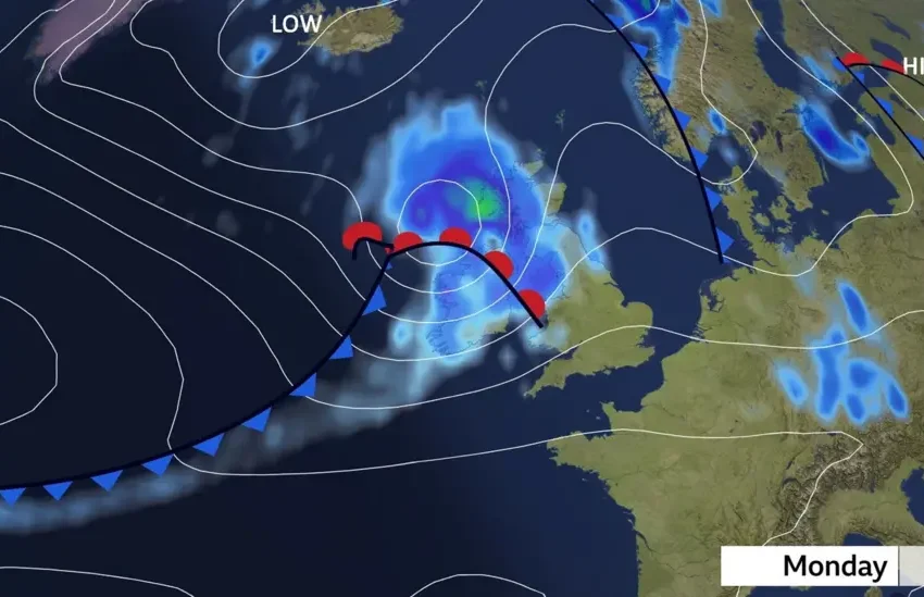
Current forecasts suggest that Storm Floris will travel across the northern half of the United Kingdom, with the strongest winds likely along its southern and western flanks. Gusts could reach speeds of 60 to 70mph in many exposed areas, especially in Scotland and parts of Northern Ireland. Coastal areas might see even stronger gusts, possibly reaching up to 85mph. Even inland locations aren’t immune—residents in northern England, southern Scotland, and central areas could experience winds in the 40 to 50mph range. Parts of southern England may also be affected, with gusts between 40 and 45mph.
In addition to strong winds, Floris is expected to deliver heavy rainfall. Localised flooding, especially in low-lying and urban areas, is a possibility. Saturated ground from recent rain increases the risk of surface water flooding, blocked drains, and river overflow.
Weather Warnings and Alerts
The Met Office has issued a yellow weather warning for wind covering the northern half of the UK. This warning is active from 6:00am Monday to 6:00am Tuesday. Yellow warnings indicate that there is a potential for low-level disruption and that the public should be aware of changing conditions. The warning urges caution, especially for those travelling, working outdoors, or relying on infrastructure that may be sensitive to high winds or water accumulation.
Travel and Infrastructure Concerns
One of the major risks associated with Storm Floris is travel disruption. High winds can lead to dangerous driving conditions, especially on bridges, open roads, and coastal routes. Public transport—particularly rail and ferry services—may experience delays or cancellations. Motorists are advised to plan ahead, reduce speed when driving in gusty conditions, and avoid non-essential travel in affected areas if conditions worsen.
Trees are more vulnerable at this time of year because they are in full leaf. That makes them more susceptible to wind damage than in winter when their branches are bare and offer less resistance. Broken branches, falling trees, and flying debris could pose serious risks to safety and property. Temporary outdoor structures such as gazebos, marquees, and tents—common during summer events—are also at significant risk and should be secured or dismantled where possible.
Power Outages and Property Damage
Power lines may be damaged due to falling trees or debris, and minor power outages are possible in areas facing the most intense gusts. Residents should charge essential devices ahead of the storm, stock up on basic supplies, and prepare for potential interruptions to electricity or mobile network services.
Roofs, fences, and garden furniture may also be affected. Property owners are advised to check their surroundings, secure loose items, and close windows, doors, and gates to reduce the risk of wind damage. Emergency services and local councils may also put response teams on standby in anticipation of damage or blocked roads.
Are Summer Storms Unusual in the UK?
While strong storms are more commonly associated with the autumn and winter months, they are not unheard of during summer. In fact, recent years have seen several significant storms strike in August. For example, in 2023, Storm Lilian caused widespread disruption just before the bank holiday weekend, cancelling flights and closing music festivals. That same month, Storm Antoni brought severe weather to parts of England and Wales, followed closely by Storm Betty.
In 2020, the UK experienced two particularly notable August storms—Ellen and Francis. These storms delivered wind gusts of nearly 80mph, leading to transport chaos, power outages, and coastal flooding. The trend suggests that while summer storms may feel unusual, they are becoming increasingly common as the climate changes.
Why Storm Floris is a Bigger Deal This Summer
What makes Storm Floris especially impactful is the time of year. Summer storms can be more damaging than winter ones because of their unexpected nature and because the environment—trees in leaf, summer events, and lighter infrastructure—is less prepared for extreme weather. Additionally, more people tend to be outdoors in summer or travelling for holidays, increasing the potential for disruption and harm.
Moreover, warm sea surface temperatures around the UK—currently 1.5 to 2°C above the seasonal average due to an ongoing marine heatwave—can fuel the intensity of such storms, providing more moisture and energy as they develop.
The Bigger Picture: A Warming Climate
Storm Floris also offers a stark reminder of the changing climate. The UK just recorded its fifth warmest July on record, with all four nations experiencing one of their top 10 hottest Julys. July 2025 was also the sixth consecutive month of above-average temperatures, highlighting a consistent warming trend. Rainfall patterns, too, have become more erratic. While some regions like Kent saw nearly double the normal amount of rain in July, others like Dorset recorded less than half the average.
These extremes suggest a future where milder, wetter winters and hotter, drier summers become the norm—alongside more frequent and intense storms throughout the year.
What UK Residents Should Do
To stay safe and informed, residents should monitor local weather updates regularly through official channels such as the Met Office or BBC Weather. If you live in an area under warning, secure outdoor items, avoid unnecessary travel, and be prepared for sudden power cuts or delays in public services. Check on vulnerable neighbours and family members, especially the elderly or those living in exposed locations.
Those attending outdoor events or planning travel should contact organisers and operators to confirm any schedule changes. Businesses with temporary setups should take additional precautions or consider postponing if conditions become unsafe.
Above all, treat the warnings seriously—Storm Floris may not be unprecedented, but it carries enough potential to disrupt lives, especially if precautions are not taken.