Storm Floris set to batter UK with fierce winds and heavy rain
Storm Floris is expected to bring strong winds and heavy rain to the UK on Monday, with a yellow weather warning already issued for the northern half of the country. Photo credit: Reuters
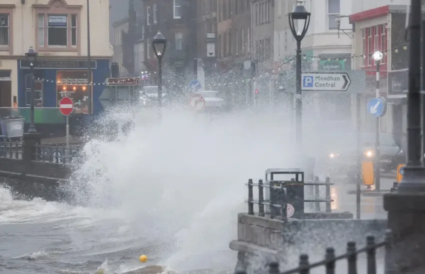
The UK is bracing for the arrival of Storm Floris, officially named by the Met Office, which is expected to strike on Monday with powerful winds and intense rainfall. This marks the sixth named storm of the current season and the first to hit since January.
Forecast models indicate that the storm’s core will move across the northern half of the country. However, the most severe conditions are likely to affect the southern and western fringes of the low-pressure system, where high-impact winds are expected.
As the storm approaches, Northern Ireland and Scotland are positioned to feel the initial force of the deepening weather system. Meteorologists warn that some northern coastal regions could experience gusts as strong as 85mph, especially along exposed coastlines and elevated terrains. Inland areas might face winds between 40 to 50mph, with parts of southern England potentially seeing gusts of 40 to 45mph as well.
In response, a yellow wind warning has been issued for much of northern Britain, covering the 24-hour period from 6:00am Monday to 6:00am Tuesday.
Interestingly, the storm’s origins trace back to a cluster of showers over the Great Lakes in the US earlier in the week. As this weather system crosses the Atlantic, it’s expected to strengthen significantly due to the influence of a powerful jet stream, rapidly evolving into a full-blown storm before making landfall.
Forecasters note that the exact path of Floris is still uncertain, and slight shifts in its trajectory could alter which areas bear the brunt of the storm. The public is encouraged to monitor weather updates closely over the weekend.
Should the winds reach anticipated speeds, disruptions to transportation and infrastructure are likely. With trees now in full foliage, the risk of them being uprooted or damaged by strong gusts is higher than during winter months. Outdoor events and temporary setups such as tents or gazebos could also face serious damage.
In addition to wind damage, heavy rainfall may lead to localised flooding and minor power outages in some areas.
Are Summer Storms Rare?
While powerful storms are more common in the colder months, summer storms like Floris are not entirely unusual. Named storms are declared by meteorological agencies in the UK, Ireland, and the Netherlands when systems are deemed potentially disruptive.
Recent summers have seen their fair share of turbulent weather. In August 2023, Storm Lilian swept across the UK just before the bank holiday weekend, affecting music festivals and air travel. Earlier that month, Storm Antoni brought severe weather to southern parts of the country, followed soon after by Storm Betty.
Going further back, Storms Ellen and Francis in August 2020 left a notable impact, with wind speeds nearing 80mph, causing coastal flooding, transport delays, and widespread power outages. These are regarded as two of the most significant August storms in half a century.
July’s Weather Recap: Heat, Rain, and a Marine Heatwave
According to provisional data from the Met Office, July 2025 was the UK’s fifth warmest on record. All four nations recorded one of their hottest Julys—Scotland and Northern Ireland had their sixth warmest, England its seventh, and Wales its tenth.
It was also the sixth straight month of above-average temperatures. The highest reading of the year so far was recorded on July 1st in Faversham, Kent, where temperatures soared to 35.8°C.
Despite slightly below-average rainfall overall, precipitation was uneven across regions. Kent recorded 86% more rain than usual, while Dorset received less than half of its average monthly rainfall.
Meanwhile, sea surface temperatures remain notably high around the UK due to an ongoing marine heatwave, with waters measuring 1.5 to 2°C above the norm.
With ongoing climate shifts, experts warn that the UK should prepare for increasingly warmer and wetter winters alongside hotter and drier summers becoming the new normal.