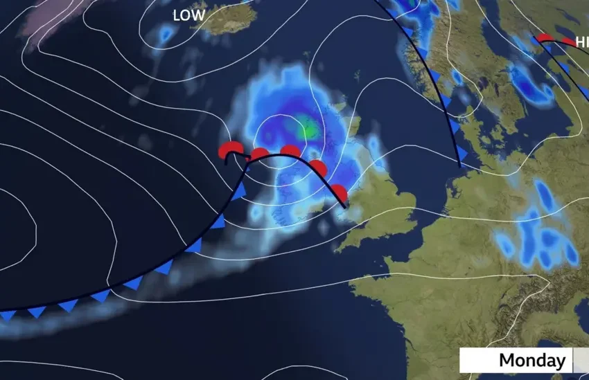
Storm Floris: Scotland, other high-risk areas in UK on Monday
Storm Floris: What UK Residents Need to Know About the Incoming Wind and Rain Warning
As Storm Floris barrels toward the UK, some regions are bracing for greater impacts than others. While much of the country will experience strong winds and unsettled weather, areas in the north and northwest—particularly Scotland, Northern Ireland, Northern England, and North Wales—are expected to bear the brunt of the storm’s fury on Monday, August 4.
With amber weather warnings issued across much of Scotland, and yellow alerts covering other northern regions, authorities are urging residents to take precautionary measures and anticipate widespread disruption to transport, utilities, and daily life.
Scotland: Ground Zero for the Storm
Amber Alert and Expected Wind Speeds
Scotland, especially the west coast, Highlands, and island communities, is at the highest risk. Forecasts predict wind gusts reaching 80–90 mph in some areas—conditions more typically seen in winter storms. The amber warning, effective from 10am to 10pm, signals a “medium likelihood” of “high impact,” including potential injuries, building damage, and power outages.
Ferry Cancellations and Isolation Concerns
The storm is already disrupting life along Scotland’s coasts. CalMac, the regional ferry operator, has issued preemptive cancellation warnings, particularly for routes connecting Oban, Mallaig, and the Inner Hebrides. This raises concerns for island residents who depend on ferries for essentials, including groceries and medical supplies.
Driving Hazards in the Highlands
Highland routes, such as the A82 (Loch Lomond to Fort William) and A9 (Perth to Inverness), are expected to be hazardous. High-sided vehicles and caravans are especially vulnerable to crosswinds. Landslides or falling trees could block roads, and visibility may be limited by spray and debris.
Urban Areas Also at Risk
Even cities like Glasgow, Edinburgh, and Aberdeen aren’t exempt. Residents can expect fallen branches, public transport delays, and the potential for power cuts that disrupt both home life and business operations.
READ ALSO
What Monday holds for UK residents as Storm Floris sweeps in
Storm Floris: What UK residents need to know about incoming wind and rain warning
Storm Floris set to batter UK with fierce winds and heavy rain
Storm Floris: Monday weather forecast for UK residents — travel disruption, others things to note
Northern Ireland: Bracing for Blustery Gusts
Northern Ireland falls under a yellow warning, with strong gusts and heavy rain expected across County Antrim, County Londonderry, and parts of Belfast. Coastal routes such as the Causeway Coastal Road could see waves overtopping sea defences, making travel risky and potentially damaging nearby infrastructure.
Commuters in Belfast and Derry should anticipate rail service delays and road closures during peak hours, while rural communities may face temporary communication blackouts if masts or lines are damaged.
Northern England: Wind and Rail Disruptions Looming
From Cumbria down to parts of Yorkshire, Northern England lies in the path of damaging winds and storm-driven rainfall.
Rail Chaos Likely
Key routes like the West Coast Main Line and the Settle–Carlisle Railway are susceptible to fallen trees, debris on tracks, and imposed speed restrictions. This could cause knock-on delays between Manchester, Leeds, Newcastle, and southern regions.
Urban Impact
Cities like Newcastle, Carlisle, and Leeds may experience damage to rooftops, scaffolding, and outdoor signage. Motorists are being advised to avoid high bridges such as the A66 over the Pennines and to avoid unnecessary travel.
North Wales: Exposed to Coastal Fury
With strong onshore winds forecast for Gwynedd, Conwy, and Anglesey, residents of North Wales are being warned to stay off sea fronts and coastal promenades. The A55 Expressway, a key route connecting the region to England, may face lane closures or delays due to fallen debris and flooding.
Communities in Bangor, Holyhead, and Llandudno could see impacts similar to those during Storm Eunice, when coastal flooding and wind damage crippled the area for days.
What’s Behind the Severity in These Areas?
Storm Floris is being driven by a deep low-pressure system forming in the North Atlantic and intensifying as it moves eastward over the British Isles. Due to the UK’s topography, the north and northwest are more exposed to Atlantic winds, with mountainous terrain creating turbulent airflow and wind funneling through valleys and coastlines.
Additionally, coastal orientation makes these areas particularly vulnerable to storm surges and wave battering, while sparser infrastructure in rural and highland zones means slower recovery times for any outages or damage.
How Residents Should Prepare
-
Secure outdoor items such as bins, garden furniture, and signage
-
Charge mobile devices and have battery packs ready in case of power outages
-
Check travel updates before setting off—many services are operating on revised timetables
-
Avoid unnecessary travel in amber warning zones
-
Stay away from coastal areas, cliffs, and sea fronts during the height of the storm
-
Report fallen trees or damage to local councils or emergency services (non-urgent lines)
A Day of Disruption and Caution
Monday will not be business as usual across the northern half of the UK. For residents in the most affected areas, Storm Floris is likely to bring a volatile mix of high winds, transport chaos, and safety risks. The storm’s unseasonal nature adds to the urgency, catching many off guard during a period typically associated with summer calm.
While the weather is expected to improve by Tuesday, the impacts may linger for days, especially in areas hardest hit. Preparedness, patience, and caution will be essential.