Life-threatening flooding hits southeast Wisconsin, roads and airports impacted
Torrential rain floods roads and shuts down runways at Milwaukee’s airport during life-threatening flash flooding in southeast Wisconsin.
Southeast Wisconsin endured a night of record-shattering rainfall, prompting the National Weather Service (NWS) to extend its flash flood warning through early Sunday, Aug. 10. The warning — now in effect until 5 a.m. for Milwaukee County and eastern Waukesha County, and 5:30 a.m. for Washington and Ozaukee counties — comes as “life-threatening flash flooding” swamps the region.
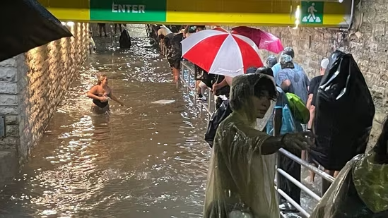
By 3 a.m., parts of Interstates 43, 41, and 94 were shut down, and Milwaukee Mitchell International Airport reported all but one runway underwater, along with flooded taxiways and an underpass tunnel.
Rainfall totals have been staggering:
-
Milwaukee: Nearly 6 inches by early Sunday
-
Butler: 10 inches — just west of Menomonee River Parkway
-
Northwest Milwaukee: Over 13 inches near W. Florist Ave., per MMSD rain monitors
The initial flash flood warning was set to expire at 2 a.m., but the NWS extended it after storms intensified unexpectedly, dumping rain at extreme rates. Between 3–6 inches fell across the region, with another 1–2 inches expected before sunrise.
Impacts have been widespread:
-
Streets, creeks, and basements flooded
-
Vehicles stranded
-
Over 38,000 We Energies customers without power
-
The Wisconsin State Fair shut down early, canceling the main stage act
-
Fallen trees in Menomonee Falls
Meteorologist Benjamin Sheppard of the NWS Milwaukee office said storms have been unpredictable in both strength and movement. The heaviest rain is expected between Saturday evening and Sunday evening, with multiple rounds of storms continuing through Monday morning.
Residents in flood-prone areas — including Milwaukee, West Allis, Wauwatosa, New Berlin, Brookfield, Oak Creek, and South Milwaukee — are urged to avoid travel on flooded roads. The NWS warns: “Turn around, don’t drown.”
Explainer: What Is a Flash Flood and Why It’s So Dangerous
A flash flood is a sudden, violent flood that happens within minutes to hours after heavy rainfall, dam or levee failure, or rapid snowmelt. Unlike regular flooding, which can develop over days, flash floods strike quickly, giving people little time to prepare or escape.
How It Happens
-
Intense Rainfall: Heavy rain overwhelms the ground’s ability to absorb water, especially in urban areas with lots of pavement.
-
Overflowing Creeks and Rivers: Small waterways can rise rapidly and spill into streets, homes, and businesses.
-
Blocked Drainage Systems: Debris in storm drains or culverts can make flooding worse.
Why It’s So Dangerous
-
Fast-Rising Water: It can turn a dry street into a dangerous river in minutes.
-
Strong Currents: Just 6 inches of moving water can knock a person off their feet; 2 feet can sweep away a car.
-
Low Visibility Hazards: Floodwater hides sinkholes, debris, and downed power lines.
Safety Tips from the National Weather Service
-
Turn Around, Don’t Drown: Never drive into flooded roads — water depth and current strength are deceptive.
-
Move to Higher Ground Immediately: If a warning is issued or you see rising water, act fast.
-
Stay Informed: Monitor weather alerts and local news during storms.
Flash floods are among the deadliest weather events in the U.S., claiming more lives each year than hurricanes or tornadoes. Their speed and unpredictability make preparation and quick action essential.