Hurricane Humberto explodes into Category 4 beast— What this means for US residents
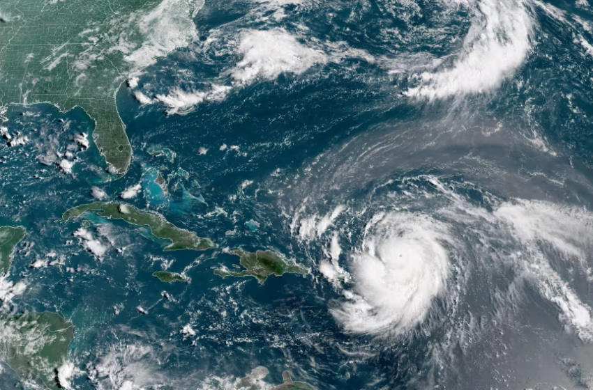
Hurricane Erin, which is the first hurricane of the 2025 Atlantic season and has developed into a dangerous Category 4 hurricane, moves westward near Puerto Rico in a composite satellite image on Saturday. Cira/NOAA/Reuters
Hurricane Humberto Intensifies, Second Storm Threatens U.S. Southeast
Hurricane Humberto surged to a powerful Category 4 late Friday, with forecasters warning that it may continue to strengthen over the weekend. The system, however, is expected to remain offshore, sparing the U.S. East Coast from direct impact.
According to the National Hurricane Center (NHC), Humberto packed maximum sustained winds of 145 mph as of 11 p.m. No coastal watches or warnings had been issued, with the storm projected to track northwest before curving north and northeast, likely passing between Bermuda and the Eastern Seaboard.
While Humberto remains a distant concern, a second weather system is drawing attention closer to home. Labeled Potential Tropical Cyclone 9, the disturbance hovered northwest of eastern Cuba late Friday and is forecast to strengthen into a tropical storm over the weekend.
The NHC cautioned that the system could reach hurricane strength as it nears the southeastern U.S. early next week. “There is a risk of storm surge and wind impacts,” the agency noted in its evening update.
A tropical storm warning was in effect for the Central Bahamas, while parts of the northwest Bahamas were under a watch. By Friday night, the system’s winds were recorded at 35 mph, just below tropical storm intensity.
Forecasters say the disturbance could deliver up to 12 inches of rainfall in eastern Cuba and between 4 and 8 inches in the Bahamas. Its projected path takes it north along Florida’s Atlantic coast and toward South Carolina by early next week.
Meteorologists added that the forecast grows less certain beyond three days, with the possibility that the storm could stall near the South Carolina coastline.
What the Twin Storms Mean for Residents of the Southeast
While Hurricane Humberto’s path is expected to remain well offshore, the presence of two strong systems in the Atlantic is a reminder that the peak of hurricane season is here—and residents along the U.S. Southeast must remain alert.
Humberto: A Distant but Powerful System
For those on the East Coast, Humberto may not bring direct impacts, but its sheer size and strength could still influence ocean conditions. Residents from Florida to the Carolinas can expect rough surf, dangerous rip currents, and stronger-than-usual waves over the coming days. Beachgoers, boaters, and coastal businesses should take precautions, even without an official warning.
Potential Tropical Cyclone 9: The Immediate Concern
The bigger threat lies in Potential Tropical Cyclone 9, which forecasters say could strengthen into a tropical storm—or even a hurricane—before nearing the Southeast early next week. For residents in Florida, Georgia, and the Carolinas, this means preparing for the possibility of:
Storm surge flooding in vulnerable coastal zones.
Damaging winds capable of downing trees and power lines.
Heavy rainfall, with flash flooding possible in already saturated areas.
Even with uncertainties in its exact track, the system’s slow movement raises the risk of prolonged rainfall, particularly around South Carolina’s coast. Communities in low-lying and flood-prone areas should be ready for extended disruptions.
What Residents Should Do Now
Monitor updates from the National Hurricane Center and local emergency management.
Review evacuation routes and emergency kits before conditions deteriorate.
Avoid complacency; storms that appear weak can intensify quickly near warm waters.
Prepare for power outages by securing batteries, water, and food supplies.
FAQ
Q1: Where is Hurricane Humberto heading?
Humberto is tracking northwest, then north and northeast, staying offshore and away from the U.S. East Coast, though Bermuda could see impacts.
Q2: Will Hurricane Humberto hit the U.S.?
No, current forecasts suggest it will remain far out at sea and not make landfall in the U.S.
Q3: What is Potential Tropical Cyclone 9?
It is a developing weather system near Cuba that forecasters expect to strengthen into a tropical storm—and possibly a hurricane—as it moves toward the U.S. Southeast.
Q4: What risks does Potential Tropical Cyclone 9 pose?
It could bring heavy rainfall, storm surge, and strong winds to Florida, Georgia, and the Carolinas early next week.
Q5: What warnings are currently in place?
The Bahamas have a tropical storm warning in the Central region and a watch in the northwest.
Q6: How much rain is expected?
Eastern Cuba may see up to a foot of rainfall, while the Bahamas could get 4–8 inches, raising the risk of flash floods.
Q7: When will the U.S. feel potential impacts?
The Southeast could see effects by Monday or Tuesday, with uncertainty about whether the system will stall near South Carolina.
Q8: What should residents do now?
Stay updated with forecasts, prepare for possible power outages, and have storm kits ready in case conditions worsen.