Hurricane Erin weakens to category 3 but expected to regain strength… what this means
Developing tropical storm near Cabo Verde could become Hurricane Erin this week.
Hurricane Erin has lost some strength but continues to loom as a dangerous system in the Atlantic. Overnight, the storm weakened to Category 3 status, yet with sustained winds near 125 mph, it remains a powerful hurricane, according to the National Hurricane Center’s early morning update.
Forecasters caution that the dip in intensity is likely short-lived. Erin is undergoing an eyewall replacement cycle—a natural process that temporarily reduces wind speeds before typically fueling re-intensification.
As of Sunday morning, the storm was positioned about 140 miles north of San Juan, Puerto Rico, and roughly 330 miles east-southeast of Grand Turk Island, moving west-northwest at 14 mph. Outer rainbands have continued to lash Puerto Rico and the U.S. Virgin Islands with downpours and gusts topping 40–50 mph. Radar estimates show 3–6 inches of rainfall across St. John and St. Thomas, while northern Puerto Rico has recorded 2–4 inches so far. These totals have triggered flash flood warnings, with the potential for landslides and mudslides where soils are saturated. Flood watches are expected to remain active into Monday morning, as isolated rainfall totals could still climb toward 8 inches in some locations.
Tropical storm warnings have been issued for the Turks and Caicos Islands, where Erin’s bands will brush the islands with squalls and heavy showers. Watches are also in place across parts of the southeastern Bahamas.
Conditions are forecast to gradually improve in the Virgin Islands by late afternoon and in Puerto Rico by tonight. Erin is then expected to slow its forward speed and gradually curve northward early in the work week, steered by a weakening Bermuda High and an approaching cold front along the U.S. East Coast.
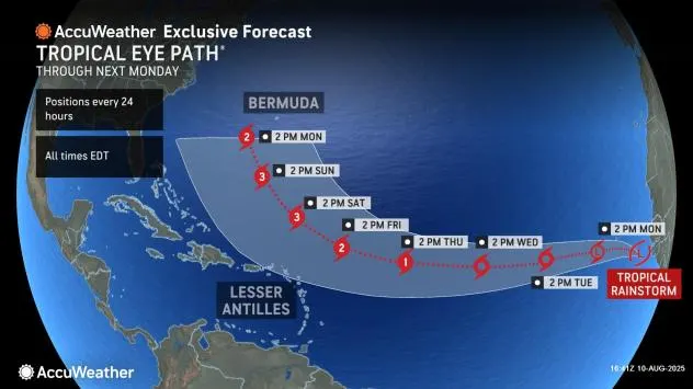
Forecast models remain consistent in projecting Erin to track between Bermuda and the U.S. mainland, reducing the likelihood of a direct hit. Still, its large circulation will generate hazardous marine conditions. Swells and rip currents will spread northward along the U.S. coastline from Florida’s Space Coast through New England. By mid to late week, wave heights of 8–12 feet are possible along the Carolina shoreline, raising concerns over coastal erosion and the safety of beachfront communities.
Although the mainland is not currently in Erin’s direct path, the storm’s sheer size ensures its presence will be felt far beyond its center, both in the Caribbean and along the Atlantic seaboard.