Hurricane Erin slams North Carolina coast: Floods, highway shutdowns, and dangerous rip currents
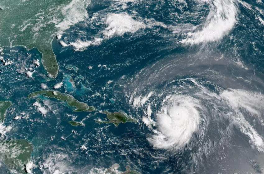
Hurricane Erin, which is the first hurricane of the 2025 Atlantic season and has developed into a dangerous Category 4 hurricane, moves westward near Puerto Rico in a composite satellite image on Saturday. Cira/NOAA/Reuters
Hurricane Erin stayed well off the U.S. coast but still packed a punch overnight, sending massive waves crashing into North Carolina’s Outer Banks and forcing officials to close stretches of N.C. Highway 12 after overwash covered nearly 50 miles of roadway.
Evacuations and Emergency Orders
Though the storm never made landfall, three coastal counties issued mandatory evacuation orders, and North Carolina Governor Josh Stein declared a statewide emergency. At a press briefing Wednesday, Stein warned residents not to ignore evacuation orders.
“When there is flooding, there is a great risk of death. We urge anyone still on Hatteras or Ocracoke to leave while they can,” the governor said.
To prepare, state and local agencies deployed 200 National Guard troops, three swift-water rescue teams, boats, high-clearance vehicles, and aircraft to at-risk communities. Shelters were also opened inland for displaced residents.
Highway and Beach Impacts
Photos and drone footage showed water spilling across N.C. Highway 12 and storm surge flooding beachfront hotels. Forecasters warned that tides and waves reaching up to 12 feet could cause further beach erosion and dangerous conditions along the barrier islands.
Wrightsville Beach officials reported nearly 80 water rescues in two days due to rip currents. By midweek, lifeguards had ordered the public to stay out of the ocean through Friday.
“These swells are producing extremely hazardous rip currents,” said Sam Proffitt, director of Wrightsville Beach Ocean Rescue. “For your safety, please stay out of the water.”
Storm Warnings
A Tropical Storm Warning stretched from Cape Lookout, North Carolina, northward to the Delmarva Peninsula. While Erin’s winds weakened from its former Category 5 peak to 110 mph on Wednesday, forecasters stressed that storm surge and coastal flooding—not wind—posed the greatest threats.
Unfortunately, Hurricane Erin's storm surge was too much for NC12 tonight. We will be CLOSING NC12 from Oregon Inlet to Hatteras Village at 6:30 p.m. Conditions are too unsafe for people to be driving in. If you come across any flood waters, turn around, don't drown. #ncwx pic.twitter.com/Osh15AFMT5
— NCDOT NC12 (@NCDOT_NC12) August 20, 2025
Where Erin Is Headed?
The National Hurricane Center said Erin made its closest pass to the U.S. at about 200 miles offshore before continuing northeast. The storm is expected to transition to a post-tropical cyclone over the weekend as it tracks between the East Coast and Bermuda, eventually brushing past Atlantic Canada.
Analysis: How Residents Can Stay Safe Amid the Storm
With Hurricane Erin disrupting daily life, experts stress that survival hinges on preparation and awareness. Here are key safety tips:
-
Avoid Flooded Roads: Even shallow water can sweep away cars. Motorists should stay off highways marked as unsafe.
-
Follow Evacuation Orders: Local authorities issue them only when danger is imminent. Delaying evacuation could put lives at risk.
-
Secure Homes: Sandbags, sealed windows, and removing loose outdoor items can help reduce property damage.
-
Stay Updated: Reliable sources like the National Weather Service and local emergency alerts should guide decisions—not rumors on social media.
-
Beware of Rip Currents: Swimmers and surfers should avoid beaches until conditions stabilize, as powerful currents can drag even strong swimmers far offshore.
Hurricane Erin is a stark reminder that nature’s fury often outpaces human control. For residents, the coming days are not just about weathering the storm—but about taking every step possible to stay alive.