Hurricane Erin likely? Tropical rainstorm in Atlantic expected to strengthen
Developing tropical storm near Cabo Verde could become Hurricane Erin this week.
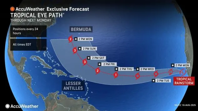
A developing tropical system in the Atlantic is showing signs of rapid organization and could become the season’s first hurricane before the week ends, according to AccuWeather meteorologists.
The disturbance, which originated as a cluster of showers and thunderstorms off the African coast last week, strengthened into a tropical rainstorm on Sunday morning near the Cabo Verde Islands. Conditions over the Atlantic — including warm waters, minimal wind shear, and the absence of Saharan dust — are expected to help it intensify. If named, it will be called Erin and could reach hurricane status by late week. The historical average date for the first hurricane of the season is August 11.
While the system tracks westward early in the week, the Cabo Verde Islands may experience locally heavy rainfall and gusty winds. AccuWeather rates the potential impacts at less than one on its RealImpact™ Scale for the region. By late week, forecast models indicate a likely turn to the north, keeping the storm away from the U.S. East Coast, though rough surf and dangerous rip currents may develop along beaches next weekend into early the following week.
Other Systems on the Radar
Meteorologists are also monitoring two additional areas in the Atlantic for potential development. One is located in the central Atlantic with a low chance of forming into a tropical system early to midweek and no expected land impacts. The other, a cluster of thunderstorms projected to move off the African coast later this week, may require closer monitoring for possible Caribbean effects.
The 2025 Atlantic hurricane season has already produced four named storms, including Tropical Storm Dexter, which formed in early August and remained over open waters.