Derecho threat looms as severe storms target US northern plains
Derecho threat looms over the northern Plains with winds up to 90 mph, flash floods, and tornadoes expected.
A dangerous round of severe thunderstorms is expected to rip through the northern Plains of the United States this Monday, driven by intense midsummer heat and stifling humidity. Meteorologists are sounding the alarm that these storms may evolve into a derecho — a rare, fast-moving system capable of causing widespread and long-lasting wind damage across hundreds of miles.
Derechos are not your average thunderstorms. They are defined by their ability to maintain strength over long distances, producing sustained and damaging winds — often on par with a hurricane. These weather events usually occur only once or twice annually, primarily during the summer months, and are most common in the Midwest and along the Mississippi–Ohio Valley corridor.
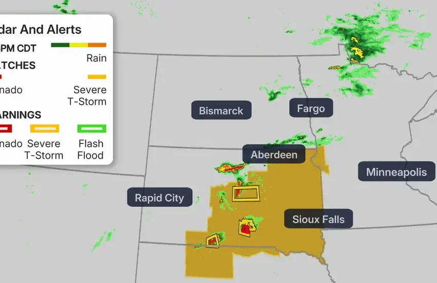
The Storm Prediction Center (SPC) has issued a Level 4 out of 5 risk alert for severe weather on Monday across parts of South Dakota, Minnesota, and Iowa. This elevated threat level is largely due to the possibility of wind gusts reaching up to 90 miles per hour — speeds typically associated with a Category 1 hurricane, though the storm’s winds will not be sustained over time as in tropical systems. Category 1 hurricanes pack minimum sustained winds of 74 mph, so any gusts approaching or exceeding this threshold can cause significant destruction.
In addition to damaging winds, forecasters warn that a few tornadoes may form within the leading edge of these storms, making the situation even more precarious. Embedded tornadoes in derechos can catch communities off guard due to the chaotic and fast-developing nature of these systems.
Surrounding the Level 4 high-risk zone, a broader swath including North Dakota, South Dakota, Nebraska, Minnesota, and Iowa is under a Level 3 of 5 severe weather risk. These areas could also experience damaging straight-line winds, large hail, and isolated tornadoes. Further extending beyond that, a Level 2 risk stretches across much of the northern Plains and parts of the Midwest. While wind remains the primary concern, forecasters are not ruling out additional tornadoes or sizeable hailstones in these zones.
Earlier Monday, parts of North Dakota experienced the first signs of the incoming disturbance, with some thunderstorms producing wind gusts up to 76 mph. As the day progressed, more storms began developing near the border of Montana and the Dakotas, moving eastward through the region. With hot, humid air firmly entrenched over the area, these storms are likely to intensify later in the day and continue into the evening hours.
The derecho, if it forms, is expected to reach its most powerful stage sometime Monday evening as it sweeps through eastern South Dakota and southern Minnesota before charging into Iowa. Meteorologists believe the storm line will weaken somewhat overnight as it nears the Great Lakes, but not before unleashing its most severe impacts earlier in the evening.
This new threat comes on the heels of a volatile weekend in the same region, where a combination of severe thunderstorms and tornadoes battered communities. Eastern South Dakota, southern Minnesota, and northern Iowa all reported storm-related damages. Three tornadoes touched down in rural parts of the Plains, while areas around Minneapolis-St. Paul were pummeled by golf ball-sized hail, felled trees, and flash flooding.
The saturated soil from these earlier storms has only compounded the region’s vulnerability. Monday’s fresh round of storms brings an added risk of flash flooding, especially in low-lying and urbanized areas. The Weather Prediction Center has placed the northern Plains under a Level 2 of 4 flood threat for excessive rainfall.
Looking ahead, the risk of severe weather is expected to shift slightly on Tuesday, moving toward the central Plains and the Great Lakes. While the threat level will reduce to a Level 1 out of 5, the system still poses a chance of isolated severe storms and continued flooding — this time further south and east. The central Plains will need to be especially cautious, as saturated ground conditions and additional rainfall could trigger new flash flood episodes.
Communities in the path of these storms are urged to stay alert, have multiple ways to receive warnings, and be prepared to take shelter at short notice. Derecho events often travel rapidly and with destructive force, and even short bursts of hurricane-strength winds can tear off roofs, uproot trees, and cause prolonged power outages.
The SPC and National Weather Service continue to monitor the evolving situation closely, and updates will be issued throughout the day as more data becomes available. For residents in affected areas, the message is clear: stay weather-aware and prioritize safety.
What Is a Derecho?
A derecho (Spanish for “straight ahead”) is an intense and fast-moving cluster of thunderstorms, known as a mesoscale convective system, that unleashes widespread straight-line winds. Unlike tornadoes, which involve rotating winds, derechos produce sustained, linear high-speed gusts—often exceeding 58 mph, with isolated gusts of 75 mph or more, along a continuous swath of at least 400 miles and a width of at least 60 miles according to the modern Storm Prediction Center definition.
How Do Derechos Form?
Derechos typically emerge during late spring and summer, when a “heat dome” of hot, humid air meets strong upper-level jet-stream winds. This setup fosters instability, rapid storm formation, and long-lived systems that produce powerful bow-echo radar signatures. The resulting storm bands can sweep across large areas, propelled by strong gust fronts generated at the leading edges of thunderstorms.
Why Are Derechos So Destructive?
The primary damage from a derecho comes from downbursts—sudden bursts of straight-line wind that fling debris outward in a massive area. These winds can strip buildings, snap trees, knock down power lines, and trigger flash flooding. Derechos rival hurricanes in damage potential, yet often strike with little public awareness