What Monday holds for UK residents as Storm Floris sweeps in
Storm Floris: What UK Residents Need to Know About the Incoming Wind and Rain Warning
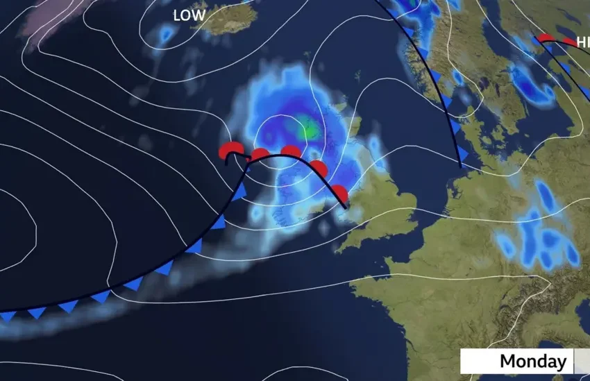
As Monday dawns, the UK is preparing to face the full force of Storm Floris, a volatile weather system set to shake up routines, travel schedules, and even power supplies across large swathes of the nation. With amber weather warnings issued for Scotland and yellow alerts stretching across Northern Ireland, north Wales, and parts of northern England, the storm has already disrupted the peace before the workweek begins.
But beyond the standard forecast, what does Monday really look like for residents? From wind-lashed coastlines to the commuter chaos expected inland, here’s a layered breakdown of what to expect and why this storm is being treated with seriousness by authorities.
An Unseasonal Jolt: Timing Matters
Storm Floris stands out—not because the UK is unaccustomed to harsh weather, but because of when it is arriving. August typically offers mild, settled summer conditions, not gusts of up to 90mph and ferry cancellations.
Coming in the middle of the holiday season, when families are heading to coastal getaways and tourists are traversing scenic routes, the storm’s timing raises the stakes. Monday, often the busiest day for travel resumption, is likely to see a significant mismatch between expectations and reality.
READ ALSO
Storm Floris: What UK residents need to know about incoming wind and rain warning
Storm Floris set to batter UK with fierce winds and heavy rain
Storm Floris: Monday weather forecast for UK residents — travel disruption, others things to note
Geographic Spread: Who’s Most at Risk?
While the storm will be felt across many regions, Scotland is in the eye of the forecast. The Met Office has upgraded the warning from yellow to amber, indicating a “greater likelihood of impacts” and a “medium likelihood of severe effects.”
Communities along Scotland’s west coast—known for its rugged terrain and exposed roads—are most vulnerable. Ferry services operated by CalMac are already signalling cancellations, while transport authorities are warning motorists to avoid open highland routes where gusts could topple high-sided vehicles.
Northern Ireland, northern England, and north Wales aren’t spared either. Although these areas remain under a yellow warning, the risk of damage from debris, fallen branches, and potential flash flooding is real—especially in rural areas with less storm infrastructure.
Commute Chaos: Delays on Every Front
Roads: Drivers should brace for longer travel times and unexpected detours. Breakdown services are advising people to secure roof boxes and trailers, reduce speed, and be extra cautious near tree-lined or coastal routes.
Rail: National Rail has warned of delays and cancellations. Speed restrictions are expected on many lines, particularly in the north, to minimize the risk of derailments due to wind-blown debris.
Airports: While not yet officially grounded, flights from regional hubs like Edinburgh, Glasgow, and Newcastle could face delays. Crosswinds during takeoff and landing pose challenges, and even minor visibility issues could cascade into major scheduling conflicts.
Ferry: Perhaps the hardest hit, ferry travel across the Scottish isles is already being scaled back. CalMac’s early warnings suggest a day of disrupted sailings, impacting both tourists and residents in remote communities.
Power at Risk: The Utility Challenge
With wind gusts likely to topple trees and down power lines, power outages are a real threat—particularly in rural or forested regions. Past storms of similar strength have caused blackouts affecting thousands, and with telecoms infrastructure also vulnerable, some areas could see temporary disruptions in mobile phone coverage and internet connectivity.
Utility companies are on standby, but the scale and access to affected areas may limit rapid response.
Coastal Hazards: More Than Just High Winds
Residents in coastal areas are being warned not just about strong winds but about large waves and flying beach debris. Sea fronts, promenades, and low-lying coastal roads are at risk of being overtaken by waves, with storm surges capable of damaging property and infrastructure.
Those tempted to sightsee or capture the drama on camera are being strongly advised to stay indoors and off the beaches—conditions could shift dangerously with little warning.
What You Can Do: Practical Preparedness
For those living in or traveling through affected areas, Monday isn’t just another windy day—it demands situational awareness. Authorities are urging residents to:
-
Charge devices and have backup batteries
-
Avoid non-essential travel, especially in exposed or coastal zones
-
Tie down or bring in garden furniture, bins, and loose outdoor items
-
Check transport schedules before setting out
-
Stock up on essentials if living in rural areas prone to isolation
Looking Ahead: A Brief But Brutal Storm
The good news? Storm Floris, while intense, is expected to be short-lived. Winds should begin to ease from the west by late Monday evening, allowing recovery efforts to begin almost immediately. But the storm’s brevity doesn’t diminish its potential for damage.
The Bigger Picture: Climate Signals?
Storm Floris is part of a growing trend of off-season extreme weather events in the UK. Meteorologists have increasingly observed that the traditional “storm season” boundaries are blurring. This shift adds complexity to emergency planning and reinforces the need for year-round readiness.
As UK residents prepare to face down Storm Floris, Monday will be a true test of resilience, preparation, and patience. Whether it’s the disrupted commute, the howling wind rattling the windows, or the flicker of lights in a temporary outage—this isn’t a storm to brush off.
Instead, it’s a call to stay informed, stay safe, and—if possible—stay indoors.